Avenza Maps: Offline Mapping
- 4.5
- Rating
- 5.00M
- Installs
- Free
- Price
 Analysis by App-foxy
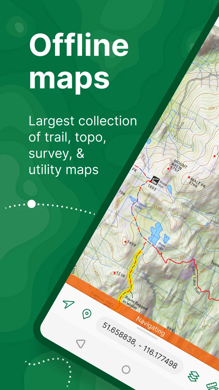
I first appreciated Avenza Maps when I stopped treating it like a regular turn-by-turn navigation app. It is better understood as a map-reading tool for situations where the map itself matters: a hiking route, a topographic sheet, a survey plan, or a downloaded guide that I need to consult away from reliable mobile coverage. That difference is important. If I only want the quickest drive to a restaurant, I would usually choose a conventional road-navigation service. If I want to see my position on a detailed map while walking beyond the normal road network, this app makes much more sense.
Developed by Avenza Systems Inc., this free Maps & Navigation app combines offline map access with GPS positioning. It is available to everyone from an age-rating perspective, runs on operating systems from version 10 onward, and currently sits at version 5.5. Its average rating is 4.7 from around 105 thousand ratings, while more than 5 million people have installed it. Those figures suggest a mature and widely used tool, but my experience is that its value depends heavily on choosing suitable maps and preparing before leaving home.
How it works in a shared household
A realistic household example is a weekend walk where one person plans the route, another carries the phone, and a third family member wants to know where the group is going. In that situation, Avenza Maps can be useful because the important information can remain on the device instead of depending entirely on a live data connection. I can open the downloaded map, view the trail network, and use the phone’s location to understand where I am in relation to the printed or digital map.
You May Also Like

 Blood Strike: 2.5 Anniversary
Blood Strike’s Loadouts Turn Every Drop Into a Tactical Gamble
A close look at Blood Strike’s custom loadouts: how fast access to signature weapons reshapes its battle royale rhythm, rewards preparation, and narrows the gap between fights.

 Pandora - Music & Podcasts
Pandora’s Music Is Easy to Start, but Harder to Recover
Pandora’s strength is its low-effort path from a seed to a station. Its weak spot is how much confidence it asks you to place in connection, setup, and quiet recovery.

 8 Ball Pool
 Is Built on Rivalries, Rematches, and Routine
A close look at the rivalries, rematches, shared routines, and unanswered safety questions that turn a quick pool match into a persistent mobile community.

 Samsung Music
’s Quiet Strength Is Playing What You Already Own
Its reach comes less from spectacle than from dependable access to a personal library. That simplicity is both the app’s strongest retention engine and its ceiling.

 AccuWeather: Weather Radar
AccuWeather Review: A Quick, Clear Forecast for Everyday Decisions
For everyday plans, the best forecast is the one you can understand quickly. AccuWeather makes rain timing, radar, and local conditions easy to act on, with a few trade-offs.

 Hill Climb Racing
Why Hill Climb Racing Still Turns Crashes Into One More Run
A tiny car, a bumpy hill and one more upgrade: Hill Climb Racing keeps resurfacing because its simple chaos makes every near-miss feel personal.
More From Our News Desk



That workflow is different from simply entering a destination and following spoken instructions. The app encourages me to inspect the terrain, identify junctions, and make decisions from the map. For a shared outing, this is a strength: the person holding the phone does not have to be the only person who understands the plan. Passing the screen around can make the route easier to discuss, especially when a family is deciding whether to continue, turn back, or choose an alternative trail.
There is also a useful distinction between a shared device and shared responsibility. A phone carried by one adult can serve as the group’s reference point, but I would not treat the app as a substitute for telling someone at home where the group is going. Offline mapping helps with access to the map and location display; it does not automatically create a complete emergency communication system.
For a household that uses one older phone for walks, travel, or outdoor projects, the free download is appealing. The main investment is preparation rather than a subscription decision. Some map content and optional purchases can cost money, with in-app items ranging from $0.99 to $249.99 each, so I would review the specific map or package before confirming a purchase. That range is broad enough that a shared device should not be left unattended during browsing if children or guests might tap through map-store choices.
Why offline preparation changes the experience
The most important habit is downloading and checking a map before the trip. I would not wait until standing at a trailhead with weak reception. A map that has been opened successfully at home is far more useful than one I merely assume will be available later. I also like to zoom into the parts of the route that matter, because a map can look clear at one scale and become difficult to interpret at another.
My practical routine would be simple: choose the area, download the relevant map, put the phone into the same general setup I expect to use outdoors, and inspect the route from start to finish. I would then check the device’s battery, screen brightness, and available storage. This is not a flaw unique to Avenza Maps; it is the normal trade-off of relying on a phone for field navigation. The app can make the map available offline, but the phone still needs power and the map still needs to be prepared correctly.
A non-obvious benefit is that offline use can reduce the pressure to keep searching the web while walking. Instead of repeatedly waiting for tiles or trying to load a page, I can focus on the map already stored on the device. That feels especially helpful in wooded areas, rural roads, large parks, and places where coverage changes from one bend to the next.
Account boundaries and household setup
When several people use the same device, I would keep the arrangement deliberately simple. One person should be responsible for downloading maps and checking purchases. Everyone else can use the map for orientation without changing the preparation. This avoids a common household problem: one user changes a setting or removes content, and the next user assumes the map is still ready.
I would also separate planning from navigation. Before leaving, the person organizing the trip can review the route and explain the important landmarks. During the walk, the phone carrier only needs to consult the map and location display. This division makes the app easier for children or less experienced map readers, because they are not expected to understand every planning choice at once.
The app is not the right choice if a household expects a fully managed family-navigation system with automatic supervision, shared live itineraries, or child-specific controls. I would not assume those functions simply because the app displays maps and GPS information. Its strongest role is map access and field orientation, not household administration.
Coordination on the move
Coordination is where I see the clearest difference between this app and ordinary navigation alternatives. A road-navigation app is excellent at telling me which turn to take next on a mapped street. Avenza Maps is more useful when the route is represented by lines, contours, boundaries, landmarks, or survey information rather than a sequence of spoken road instructions.
For example, on a trail I may need to recognize that I am approaching a junction, compare the map with the surrounding landscape, and decide whether a side path is part of the planned route. The app supports that style of thinking better than a car-focused navigator. It also suits people who already receive or use specialized maps for outdoor recreation, land management, fieldwork, or surveying.
In a group, I would appoint one person to make route decisions and another to keep an eye on the surroundings. Constantly passing the phone between walkers can be awkward and can drain attention from the path. A better approach is to stop at safe points, orient the screen, discuss the next section, and continue. This is a small workflow change, but it makes the app feel much more dependable.
Another useful trade-off is detail versus simplicity. A topographic or specialist map may show information that a standard navigation app omits, but that additional information can be harder for a casual user to interpret. Contour lines, boundaries, symbols, and multiple route options are valuable only when the group understands what they mean. I would introduce the map at home rather than handing it to a first-time user at the most confusing junction.
Using the app for everyday errands and projects
Avenza Maps is not limited to long hikes. I can imagine using it for a visit to a large park, a property inspection, a community cleanup, or a trip through an unfamiliar rural area. In those cases, the offline map can act as a visual reference when a normal street map does not show enough context. The app becomes particularly practical when the destination is not a conventional address.
For a shared household project, one person could prepare the map while another records observations or checks landmarks. The important point is to agree on what the map is being used for. If the goal is simply to reach a shop by car, the usual alternative will probably be faster. If the goal is to understand a mapped area and relate the phone’s position to that map, Avenza Maps is the more natural tool.
I would also avoid using it as the only source of truth in a situation where a mistake could have serious consequences. GPS positioning is helpful, but a displayed position does not remove the need to read signs, watch the terrain, respect closures, and carry sensible backup information. The app improves access to a map; it does not guarantee that the map is current, that every path is open, or that the user has interpreted it correctly.
Age, trust, and responsible use
The Everyone content rating makes the app approachable for a household with different age groups. However, age suitability and navigation readiness are not the same thing. A child may be perfectly capable of looking at a map while still needing an adult to decide which route is safe. I would let younger users explore the map at home, identify symbols, and help compare landmarks, but I would keep final route choices with the responsible adult.
Trust also matters when the app is installed on a shared phone. A person who downloads a map should tell the rest of the group which area is covered and whether the map is intended for offline use. I would not assume that another family member knows what was prepared, especially if the device is passed between people or used for several trips.
Because optional purchases are available, I would make the purchase boundary clear before handing over the phone. The app itself is free, but that does not mean every map-related option is free. A shared-device routine should include a quick check of what is being selected and whether it is necessary for the planned outing. This is less about restricting exploration and more about preventing an accidental purchase caused by a curious tap.
Privacy expectations should also be realistic. A map app that uses GPS can reveal where the device is, so I would think carefully about who carries it and who can view the screen. In a family setting, that may be straightforward. In a shared group or borrowed-device setting, I would avoid treating location information casually. The app can support coordination, but the people using it still need to agree on how location details are handled.
Where the alternatives are better
For city driving, public-transit directions, traffic-aware routing, and business searches, a mainstream navigation app is usually the better fit. Those services are built around live road information and quick destination entry. Avenza Maps asks me to work more directly with the map, and that is not what every user wants on every trip.
For hiking, the comparison is more balanced. A specialized trail service may offer a more guided experience, while Avenza Maps is attractive when I already have a particular map sheet or need a more traditional cartographic view. Its advantage is not that it replaces every outdoor app; it is that it gives the map itself a central role.
For professional surveying or fieldwork, I would judge the app against the exact workflow rather than its general reputation. It may be convenient for viewing and navigating with suitable maps, but a team with strict data-collection, export, or equipment requirements should test the complete process before relying on it. The broad price range for optional items also means that professional users should evaluate the relevant purchase carefully instead of assuming the free installation covers every need.
Small habits that make it more reliable
My first tip is to prepare a route in daylight and with enough time to correct mistakes. A map that looks obvious on a large screen can be less comfortable to read on a phone outdoors. I would identify the start, finish, major junctions, and likely turnaround points before leaving.
My second tip is to use the app as a conversation tool, not just a personal screen. At a junction, I would show the map to the group, explain the next landmark, and then put the phone away while walking. This reduces distraction and helps everyone understand the plan.
My third tip is to keep the original context of a downloaded map in mind. If it is a topographic sheet, I would learn its symbols before the trip. If it is a survey-oriented map, I would not assume that a casual hiker will interpret every line correctly. The app can display specialized information very well, but the user’s map literacy determines how useful that information becomes.
My fourth tip is to test the exact device that will be carried. A map prepared on one phone may not be available in the same way on another shared device, and a family should not discover that distinction at the trailhead. I would make the final check on the phone that will actually travel.
My household verdict
After using it as an offline map and GPS companion, I see Avenza Maps as a focused tool rather than a universal navigator. I would recommend it to households that hike, explore parks, work with topographic material, or need to consult specialized maps away from dependable connectivity. It is especially good when one person prepares the map and the group uses it together for orientation.
I would skip it for a family that mainly wants automatic driving directions, live traffic, simple business searches, or a completely guided route with minimal map reading. I would also be cautious about making it the sole navigation method for demanding trips. Its limitations are manageable, but only when the household accepts the need for preparation, battery awareness, map interpretation, and sensible backup planning.
The strongest reason to install it is not the promise of effortless navigation. It is the ability to carry a useful map into places where an online alternative may be inconvenient, then relate that map to the phone’s GPS position. That makes Avenza Maps a good recommendation for practical, map-minded users, provided they understand the difference between having an offline map and having every navigation problem solved.
For me, the final decision is straightforward: if your shared trips are built around trails, terrain, boundaries, or detailed map sheets, the free app is worth trying. Prepare it together, establish who handles downloads and purchases, explain the map to younger users, and keep route responsibility with an adult who can judge the surroundings. Used that way, Avenza Maps becomes a dependable household reference for offline exploration rather than another app installed and forgotten.
FAQs for Avenza Maps: Offline Mapping
01What is Avenza Maps and how does it work offline?
Avenza Maps is a mobile app designed for offline navigation and mapping. It allows users to download maps for use without an internet connection, making it ideal for hiking, traveling, or any outdoor activities. The offline capability ensures you can access detailed maps and GPS tracking even in remote areas where connectivity is limited.
02How do I download maps on Avenza Maps?
To download maps, simply browse the Avenza Map Store within the app, select the desired map, and download it directly to your device. You can access these maps anytime, regardless of your internet connection, ensuring you’re always prepared for your outdoor adventures.
03Is Avenza Maps free to use?
Avenza Maps offers a free version that includes basic features and allows you to download a limited number of maps. For more advanced features and unlimited map downloads, you can opt for a subscription. The premium version provides additional tools and functionalities for enhanced navigation and mapping experience.
04What devices support Avenza Maps?
Avenza Maps is available for both Android and iOS devices. It supports a wide range of smartphones and tablets, ensuring users can easily access and utilize the app’s features across different platforms. Always ensure your device meets the app’s technical requirements for optimal performance.
05Can I create custom maps with Avenza Maps?
Yes, Avenza Maps allows users to import and create custom maps. You can upload your own map files in formats like GeoPDF and GeoTIFF. This feature is particularly useful for professionals who require specific maps for fieldwork or personal projects, offering flexibility and customization.
Pros
- User-friendly interface for easy navigation.
- Offline maps reduce data usage significantly.
- Wide variety of map sources available.
- Accurate GPS tracking even in remote areas.
- Customizable map markers and notes.
Cons
- Limited free features; premium required.
- No real-time traffic updates available.
- High battery consumption during use.
- Occasional app crashes reported by users.
- Map downloads can be time-consuming.

Avenza Maps: Offline Mapping
Gallery